Wednesday, October 26, 2011

Searching for Byzantium

View of Golden Horn from Topkapi Palace
When I first spoke with my mother upon my return from our visit to Istanbul, I explained that it was known as Byzantium when the Greeks first founded it in the 7th century BC, but when Roman emperor Constantine made it capital of the eastern half of the Empire in the 3rd century AD, it became known as Constantinople;  finally, after the Ottomans conquered it in the 15th century they renamed it Istanbul.  Something clicked, and she started to hum an old song that played on the city's various names.  This confusion about names is not coincidental, but represents a fundamental reality about the City Formerly Known as Constantinople (and Before That as Byzantium) – Istanbul has many faces and even more layers of reality.  After nine days there, The Spouse and I realized that we had only begun to scratch the surface.

Our opportunity to visit came through a conference at one of the city’s universities related to TS’s work and we added weekends and a couple of vacation days to make a long visit.  By chance the hotel connected to the conference was located in an area called the New District.  This turned out to be perfect for our studies of Istanbul.  A vigorous walk took us to most of the “must-see” places in the Old City, but we could easily return to something closer to normal Istanbul.

I have long puzzled over how to best describe our experience.  I have not traveled as widely as some – unlike Younger Sister who was in the Peace Corps in Mali, I have never been to Africa, nor to Asia.  Istanbul – with its minareted mosques and veiled women – is easily the most exotic place I have been.  Yet, with some 18 million people, metropolitan Istanbul is a major modern city, with gleaming new underground metro stations and efficient tram and bus networks.  Beyond the facile juxtaposition of tradition and modernity is the way that the city seems to encompass both, if not effortlessly, at least in a seemingly creative tension.

View from Our Hotel Window
Perhaps the best way to illustrate what I mean is to simply describe what we saw. 
We arrived at Atatürk International Airport – named for Mustafa Kamel Paşa, founder of modern Turkey after the post-World-War I collapse of the Ottoman Empire (he became known as Atatürk,  “Father of the Turks.”)  He launched a program of social and political reform that included establishing a secular republic, introducing a Roman alphabet in place of the Arabic one, emancipating women and encouraging Western dress.  Appropriately, the airport is modern and efficient – signs, fortunately, were in English as well as Turkish.  The bus ride through the sprawling metropolitan area showed low-rise buildings, of recent, if undistinguished construction.  Our hotel in the New District was completely modern.  And yet… the man who showed us to our room confirmed our guidebooks’ warning not to drink tapwater.  Istanbul’s water is chlorinated, but everyone drinks bottled water.  It is inexpensive, but I hate to think of the vast amount of waste produced.

View of New District from Galata Bridge
We headed out to explore.  Our hotel, the Marmara Pera, stands next to the famous Pera Palace hotel, opened in 1892 by the builder of the Orient Express to provide suitable housing for European travelers.  It was placed here, on a hill across the picturesquely-named Golden Horn river/estuary from the endpoint of the Orient Express in the old city, because this area was the home for foreigners in Istanbul.  It had been that way since the 13th century when Genoese traders were allowed to settle here in return for their help in defeating Venetians who had invaded the city during the Fourth Crusade.  At that time Constantinople was still Christian, but the invading Europeans looted it anyway.  (Are you beginning to get a sense of how complicated this city’s history is?)

Taking our way down narrow cobblestone streets we pass Galata Tower, built by the Genoese in 1348 as a watchtower.  With its distinctive conical roof it is one of the few remarkable buildings on this side of the river; recently an attractive public square has been set out around its base, ringed by pleasant outdoor cafés.  We buy a packet of pistachio nuts from one of the ubiquitous street vendors and munch as we continue downhill.  (There is an underground funicular line running between the crest of the hill and the riverside, but we never take it, having been conditioned by our year in Switzerland to hill walking.)

When we reach the bottom we race across several lanes of traffic to reach Galata Bridge – vowing ever after to take the subway passage to preserve life and limb.  There is actually little automobile traffic through the narrow streets of the older parts of the city, but it all seems to have been shunted into major thoroughfares, which have few crosswalks.

From the bridge we have a striking view encompassing the oldest parts of Istanbul, the hills of the New District, and the Asian part of the city across the Bosphorus Strait.  Most buildings are only a few stories high, allowing the city’s mosques to stand out everywhere, with their massive domes and tall slender minarets.  We hear the call for late afternoon prayers.  The sound is familiar from media reproductions but still exotic, an emphatic reminder that we are not in Kansas anymore.  Instead of climbing to the top of the minarets to call the faithful to prayer, Imams now use loudspeakers, but their voices are still live not pre-recorded.  Though there are many mosques within sight, it is hard to hear the calls over the roar of traffic on the bridge.


We climb back up the hill via a street lined with small shops, most selling electronics and musical instruments, with here and there one with bright tourist trinkets.   We come to Ĭstiklâl Cadessi, or Freedom Avenue, heart and soul of the New District.  Once known as the Grand Rue of Pera, it was carved out of a maze of small lanes in the 19th century and is lined with European-style apartment buildings, some recently restored and many in need of urgent attention.  Today it is pedestrian-only and a major shopping and entertainment area, with virtually every chain store one might find in an American mall or British High Street, plus countless unique cafés, restaurants and shops.  An old-fashioned trolley runs down the middle, usually overflowing with tourists snapping photographs.  Ĭstiklâl is bustling with Saturday afternoon shoppers, but when we return after having dinner at a lovely seafood restaurant off the main drag the crowd has swelled to completely fill both sides of the street.  Clearly, this is The Place To Be for young Istanbul on a Saturday night – couples and packs of young men or women (many wearing scarves) stroll up the street, stopping to buy ice cream at a shop or an ear of corn grilled over an open fire.

On Sunday we begin our serious work as travelers, to work our way through the list of Must-See sights.  First is Haghia Sophia (Divine Wisdom), the 6th century Byzantine church built by Emperor Justinian, converted by the Ottomans into a mosque and now officially a museum.  It is dominated by a massive dome – 185 feet high and roughly 105 feet in diameter – that creates a nave with enough room to easily shelter Paris’ Notre Dame Cathedral.  Largest in the world at the time and for many centuries thereafter, the dome had many imitators – one, notably, was Venice’s St. Marks, which had so enthralled us last fall.  The Ottomans were so taken with the architectural form that for centuries it was the standard for mosques.

Much of the surface of the nave and outer rooms are covered with non-figurative mosaics, but to our disappointment few representative mosaics have survived.  Islamic tradition forbids representation of human figures and after the Ottoman conquest the Christian images were painted over.

The few that survived and were uncovered after the building became a government museum in the 1930s give some idea of the power of Byzantine iconography.


One of our guidebooks explained that many of the building’s columns had been brought there from older monuments and buildings.  Thus we were introduced to one of our favorite oddities about Istanbul – its habit of “recycling” from the past, its own and others’. 

After leaving Haghia Sophia we visited the Basilica Cistern nearby – a huge underground reservoir also constructed in the time of Justinian.  Its vaulted brick roof is held up by more than 300 stone columns, most similarly taken from other sites.  In the shadows at the far end are two columns that rest on massive carved Medusa heads, brought there from who knows what Hellenistic building.
We moved on from there past Sultanahmet Square, a broad rather dusty park standing between Haghia Sophia and the Blue Mosque, built in the 17th century for Sultan Ahmet I, as a modern answer to the older building.  It was constructed on the site of the Byzantine Great Palace, home to centuries of Roman emperors. Deciding to leave that for another day, we crossed to a long park to its north, standing on the site of the Hippodrome, the stadium that had been a focus of public life in the Byzantine capital for a thousand years.  Today all that remains is a line of monuments – ironically, all brought here from parts of the Empire.  There is a large obelisk that had stood near Luxor in Eqypt since 1500 BC until Constantine brought it to his new capital.  Near it is what remains of a 5th century BC bronze column shipped here from Delphi.  At the far end of the race track there once stood a triumphal arch topped by four massive bronze horses brought from ancient Greece – but the Venetians took them when they looted Constantinople during the Fourth Crusade.  (There they stood overlooking St. Marks Square until they were looted in turn by Napoleon in the 18th century, though they were eventually returned – to Venice.  I’d hate to be a lawyer trying to work out who rightfully owns them!)

Only remaining portion of Great Palace
We wandered past the open squares into a neighborhood of densely-built wood-frame houses and small hotels, eventually crossing an area once bounded by powerful stone walls where one can see the only surviving ruins of the Byzantine Great Palace.


Coming to the Sea of Marmara, we followed the coast back to the Golden Horn, sharing our enjoyment of the late afternoon with many city residents who were spending their Sunday afternoon on the water, fishing and picnicking and sunning themselves on the rocks.  An unending stream of freighters passed on their way to the Black Sea through the Bosphorus Strait or back into the Mediterannean.


Topkapi, Second Courtyard
Monday morning we returned to the Old City to visit its second major sight – Topkapi Palace, home of the Sultans ruling the Ottoman Empire from the 15th century until they departed for more modern quarters in the mid-19th century.  It is made up of a large complex of open courtyards, built over the original settlements on high ground overlooking the Bosphorus and the Golden Horn, impregnable behind stone walls.  The courtyards move from grand ceremonial spaces to increasingly intimate ones, where only the Sultan and a few others were allowed.

Taken as a whole, Topkapi is every bit as impressive as Versailles – both were intended to convey the enormous power of their chief resident – and is ornately decorated throughout.  There was plenty of gold and jewels on display in the Treasury, though a little of that sort of thing goes a long way with us.  (The loot included the fancy dagger that inspired the 1964 heist movie Topkapi.)   More impressive in its way was an exhibit of sacred Islamic relics, many taken from Egypt and Arabia when the Ottomans conquered them in the 16th century.  The rooms were filled with the sound of a voice chanting in Arabic, and as we left we saw a turbaned imam sitting before a microphone, where someone reads aloud from the Quran, as has been done round the clock since the 16th century.  The Quran rests on a gold chest containing a mantle worn by the Prophet Mohammed himself.

Entrance to the Harem
A visit to the Harem, or the residence of the Sultan’s household, cost an extra admission charge but was well worth it.  Far from the orgiastic sex-pad of European imaginings, the Harem is a complex network of corridors and apartments that organized the lives of everyone who lived there – the Sultan, his mother, his up to four official wives, many concubines, their children and the female slaves and male eunuchs that served them all.  Yes, I did say that the Sultan’s mother, known as the Valida Sultana, lived there – in fact, she was in charge of running the whole household.   Her large courtyard stands at the center of the Harem complex and her apartment is strategically located between that of the Sultan and those of his wives and favorites – which were most often selected by the Valida Sultana or the head wife.

View up the Bosphorus from Topkapi
The fourth courtyard is a series of gardens containing exquisite pavilions where the Sultan entertained and enjoyed the views.  Today, visitors are also able to take in the views from a spectacular terrace occupied by the Konyali Restaurant.  Although a bit expensive by Istanbul (not Swiss) standards, it was definitely worth it for the chance to take in the Bosphorus views and sea breeze. 

Haghia Eirene
Afterward we passed back through the successive courtyards, back through the First Courtyard which once was the site of much of the Empire’s government.  It also contains the 6th c. Byzantine church of Haghia Eirene (Divine Peace), a smaller sister of the Haghia Sophia, that stands on the oldest site of Christian worship in Istanbul.  The Ottomans used it as an arsenal instead of converting it into a mosque. Unfortunately, it is not now generally open to the public.

Skirting the Haghia Sophia complex, we decided it was time to pay a visit to a functioning mosque.  The great Blue Mosque, built in the 17th century, sits across Sultanahmet Square from Haghia Sophia.  Unlike the much older building, it was designed to be as impressive outside as inside; the cascade of domes rising from the western courtyard is particularly striking.

I had done my homework and carried with me a scarf and a pair of socklets – the scarf because I knew women would be asked to cover their heads, and the socks because everyone would be asked to remove their shoes.  Although I have negative feelings about the expectation in Islamic tradition that women cover up in any public space, I feel that one should respect a religion’s customs when visiting its place of worship.   The Spouse and I entered by a door reserved for visitors, removing our shoes and putting them in a bag, and entered into the huge hushed open prayer hall.

The Mosque gets its name from the predominance of blue Iznik tiles throughout.  We stood behind a wooden rail – most of the vast open space was reserved for Muslim worshipers, many of whom knelt on the carpet to say prayers.  I should say, for male Muslim worshipers, because female Muslims are relegated to worshipping in a small enclosed area behind the visitors’ area. 

 Neither TS nor I are shoppers by nature, so we paid a brief visit to the famous Grand Bazaar, a huge maze of covered lanes housing thousands of shops offering traditional wares.  We passed through a part at the end of the business day, when shopkeepers were more intent on packing up than in getting us to stop with one of their ubiquitous hook-phrases, such as “Hey, American!  Where you from?”  Whatever the answer might be, the person would have a cousin who lived there – somehow this is supposed to gain our trust.  We gradually made our way through narrow crowded streets and back to the New District.

Mosaic of the Dormition of Virgin Mary
The next morning, we took a taxi (remarkably inexpensive, we found) to the Church of St Savior in Chora, on the outskirts of the old city (“in Chora” means “in the fields”).  We headed out there because we had heard that the church had fine Byzantine mosaics and frescoes and we were not disappointed.  In fact, our visit was one of the high points of our trip.  It dates from the 11th century, with mosaics from the 14th century, full of eccentric spiritual vision of the Orthodox tradition.  Many images related to the Virgin Mary, and we learned that she is a particularly potent and popular figure in Orthodox tradition because of a long history of mother goddesses in the Mediterranean area.  One of two passages outside the nave contained lives of Christ on one side and of Mary on the other, many of the scenes based on the apocryphal 2nd century Gospel of St James.

We happily spent the morning wandering back and forth throughout the church, identifying Biblical references and taking breaks under the trees in the lovely outside garden – which also enabled us to get better acquainted with some of the city’s friendly cats.  (See accompanying guest blog by The Spouse.)


Afterward we skirted some of the remaining city walls, originally constructed in the 5th century by Emperor Theodosius II, that stretch 4 miles from the Golden Horn to the Sea of Marmara.  Beyond them we found a newly-constructed stop for Istanbul’s modern tram network, and rode it back into the Old City.  We had one remaining major goal – a thorough visit to the Archaeological Museum, which has one of the world’s richest collections of classical objects.  Both of us, but especially TS, are fascinated by ancient history and archeology.

We enjoyed many of the highlights, such as an amazing carved marble Sarcophagus from the 4th century depicting Alexander the Great in battle with the Persians.  But our favorite was a hall filled with funerary monuments put up by ordinary people – the inscriptions were so full of the feeling of real life.  We strolled across the courtyard to the exquisite Tiled Kiosk, a pavilion containing beautiful examples of this characteristically Turkish art form.
During the next few days, The Spouse tended to business – a conference at one of the city’s universities – while I took more time to explore the neighborhood and shop for Christmas gifts.  Having been warned that wares at the Grand Bazaar were likely to be of poor quality, I decided to do most of my shopping in the New District, where I it seems that most locals shopped themselves.  (Ironically, bargaining seems to have become mainly a diversion for tourists – residents prefer standard pricing policies.)

One day I walked to Taksim Square, at the end of Ĭstiklâl Cadessi.  In the center there is a monument to Atatürk and the Revolution – notable because it is one of Istanbul’s few representational monuments.  At the far end stands a huge Atatürk Cultural Center, said to house a rich variety of concerts and performances – but when I got close I realized that it was completely closed, though no explanation was given.   Ĭstiklâl runs along the crest of a hill that falls away quickly toward the Bosphorus, and one evening TS and I explored the neighborhoods lining the steep hillsides – most filled with prosperous-looking apartment buildings.

Simit Salesman, Asian Istanbul in background
Our last full day in Istanbul was a Saturday, and we decided to take a ferry to the Princes Islands, a chain of four islands south of the city in the Sea of Marmara.  It was a beautiful day and long before its scheduled departure all seats were filled with ordinary residents and a smattering of tourists like ourselves.  Groups of teenagers, some girls in scarves, some not, and couples out together for the day chattered happily around us, while hawkers offered everything from the popular Simit – like large sweetish pretzels dipped in sesame or poppy seeds – to fruit drinks and sodas. 

The Princes Islands are so-called because in Byzantine times deposed rulers and other undesirables were exiled there; in the nineteenth century they became popular resorts for Istanbul’s Greek, Jewish and Armenian communities.  There are still several Greek Orthodox monasteries, especially on the fourth and largest island Büyükada, where we eventually disembarked.  None of the islands allow automobiles, so many visitors take horse-drawn carriages.  We preferred to walk, enjoying the beautiful homes and ocean views – somehow reminiscent of Southern California.  Like much of the Mediterranean, the climate is actually quite dry, so the natural landscape is semi-arid.

We hiked to the far side of the island, where the Greek Orthodox monastery and church is something of a pilgrimage site.  People praying for the recovery of a loved one could be seen unspooling thread as they walked the cobblestone path, and at the top branches of trees were filled with ribbons symbolizing a prayer request.  Here, there were no headscarves, so presumably the pilgrims were Christians.


At the top there was also a lovely simple restaurant offering good grilled fare and some of the most beautiful views anywhere.


We left, full of impressions but no fixed opinion, vowing to return to Turkey.  It will be fascinating from now on to observe how it manages to negotiate the tensions between modernity and tradition, secular progress and religious faith.

Friday, September 16, 2011

Celebrating Schweizer Bundesfeier

The Oath, as envisioned by Henry Fuseli
Switzerland and the United States are both federations of states, or cantons, that retain a degree of independence unusual among modern nations.  Interestingly, both countries celebrate their primary national holiday on a date connected with the creation of a defensive alliance among its founding states.  Unlike the US, Switzerland’s foundation dates back so far that few facts can be known for sure.  According to tradition, representatives of Schwyz, Uri and Unterwalden cantons swore to assist each other in preventing encroachment by foreign powers, especially the Hapsburg Empire to the east.  As Wikipedia notes, the precise date might have been 1291, or 1307, or some other date, but the fact remains that it was a heck of a lot farther back that 1776.  From the original three cantons, Switzerland gradually grew into a federation of 26, embracing populations that speak four languages and many more dialects.  As far as I can see, what they most held in common was a determination to be independent of their larger neighbors, whether France, Italy, Germany or Austria.

Now Swiss National Day, August 1, is celebrated much as it is in the US, that is at the local level, with community processions, performances of traditional music and dance, fireworks and bonfires, and backyard cookouts.  But the best part has no counterpart in America, as far as I know – its popular custom of farm brunches.  Farmers all over Switzerland host (for a fee) huge breakfast/brunches in their barns and farmyards and folks come out and spend many hours eating at long tables shaded by trees or awnings.  It’s a wonderful illustration of the continuing ties here between country and city, as well as care taken to cultivate them.

Someone in The Spouse’s office alerted us to a website that listed brunches to be held all over the country, where we could reserve a place.  I chose a farm located in Unterägeri, a community just over the hill from Baar where we had hiked earlier in the spring and particularly enjoyed the rural landscape.  Pulling out my best German, I reserved three places, one for my mother who would be visiting us at the time.

Fortunately, August 1 dawned clear and sunny.  Though food would be served from 9 am to 2 pm, I had been advised to get there early, so we arrived a little after 9:30 -- only to find that many, many others had had the same idea.   


Plucky Mother and TS
We were amazed at the size of the undertaking, with hundreds of guests seated at tables set up in the barnyard and the lawn between barn and house, and a large buffet spread out in part of the barn.  Dozens of people wearing crisp white shirts and blouses bustled about refilling plates, serving drinks, and frying large pans of Rösti (a Swiss specialty, fried grated potatoes, somewhere between hash brown potatoes and potato latkes).  The operation was so massive that we concluded that the farmers in the neighborhood must have gone in together to put it on.

After a bit of time in line, we piled plates with selections from a variety of kinds of bread, cheeses, meats, fruit, preserves and butter.  We found places at a table beside a large poultry barn, and I picked up café crèmes for Mom and me – served with lots of hot milk in large bowls.  After we were seated we attracted the attention of a young woman carrying around a large plate of rösti, who gave us each a large serving, and soon after a young man with a pan full of eggs fried sunny-side up deposited one on top of each.  As we ate and drank our fill, we enjoyed the views across the green hills toward the lake, and the sight of children playing with young farm animals in pens set up nearby. 

Given that it was the national holiday I had expected to see many people dressed in red and white, the national colors, or even in traditional clothing.  But few seemed to think it necessary to display their patriotism in that way – I suppose that just partaking of the event was enough.  The only family dressed in red T-shirts with white crosses turned out to be American expats like ourselves.

As we left we expressed our appreciation in halting German to the farmwife who was obviously in charge of the operation and enjoyed the collection of chickens that decorated the beautiful traditional farmhouse. 


We spent much of the following afternoon in quietly digesting our brunch.  In the evening we decided to head down to the waterfront at Zug to see what was going on there.  Unfortunately, we arrived too late to hear the performance of traditional music; fortunately, we had already taken in an Alpenhorn concert a few days before.  


We did hear the faint strains of the national anthem as we took seats beside the water and next to a lovely gelato stand.  The city had already held a mammoth fireworks display at its Lake Fest in June, so the main official attraction was to be a large bonfire set atop a barge in the lake.  But many had decided to make up the lack of official fireworks with individual initiative, and frighteningly large fireworks were going off on the shore all around us.  Deciding that our spot was one of the most protected, we determined to make an evening of it, and paid rent for our seats through repeated visits to the gelato stand.  (It only seemed fair.)

As dusk fell we could see firework displays go off at neighboring communities all around the lake.  The bonfire rose ever higher on its barge and the voluntary aerial fireworks shot up all around.  It was a particularly beautiful and relaxing way to spend the day.


Thursday, August 18, 2011

Summer Visitors


It’s a commonplace in the expatriate community that there are two unquestionable signs of summer in Switzerland – the appearance of road construction projects and the arrival of visitors from back home.  The season arrived early this year, with plenty of warm dry weather in May, detour signs and, yes, a number of welcome guests.  Your Faithful Correspondent is a tourguide at heart, and The Spouse is an exceptionally genial host, so we enjoy having guests.  Given that we are now living in the Mountain Paradise, the only problem is to select an itinerary from among the many possible sights.  Now, in mid-August, the visitor season has come to an end, and I can offer some insights on the basis of our first summer’s experience.

An important finding is that visitors offer an excellent opportunity to re-visit places you have already been but that bear seeing in another light.  For example, taking the train to the top of Rigi has become a staple of my tours because it is nearby, introduces the visitor to the experience of traveling by mountain cog rail, and promises views of a wide swath of the Swiss Alps.  So far, I have been there four times, and each time has been different.  The first visit, faithful readers might recall, was last winter with Middle Sister, when we rose above the clouds to see the sun and the mountaintops.  In April, my 80-something aunt and a friend paid a short visit, and I took them to Rigi so they could see the Alps.  Unfortunately, the very top was socked in, but they were good sports and enjoyed the views on the way up and down.

When several good friends from Philadelphia came in May, TS and I decided to visit Rigi via paddleboat on the Vierwaldstättersee from Luzern.  It was a beautiful early summer day that offered stunning views at all stages of the trip.  We contemplated anew the fact that Switzerland is much blessed in its conjunction of lakes and mountains.

Best of all was the 360-degree view from the top.  There Rigi seems to be surrounded by water, bounded as it is on the north by the Zugersee, on the west and south by various arms of the Vierwaldstättersee, and on the east by the smaller Laurenzersee.  

My fourth ascent came at the beginning of a two-week visit from my Younger Sister, her wonderful husband, whom I will call Brother-In-Law because he’s the only one I’ve got, and my 82-year-old mother, whom I will call Plucky Mother because she’s impressively spry despite a few age-related problems.  They arrived early on the Sunday morning, after a long, uncomfortable trip from Wyoming (no thanks to US Airways).  We spent a little time that day along the waterfront in Zug, but on Monday I wanted to get them to Rigi to see the mountains – especially because rain was forecast for much of the rest of the week.  Though there were a few more clouds than on the previous visit, the views were spectacular.

The Inn's Back Garden
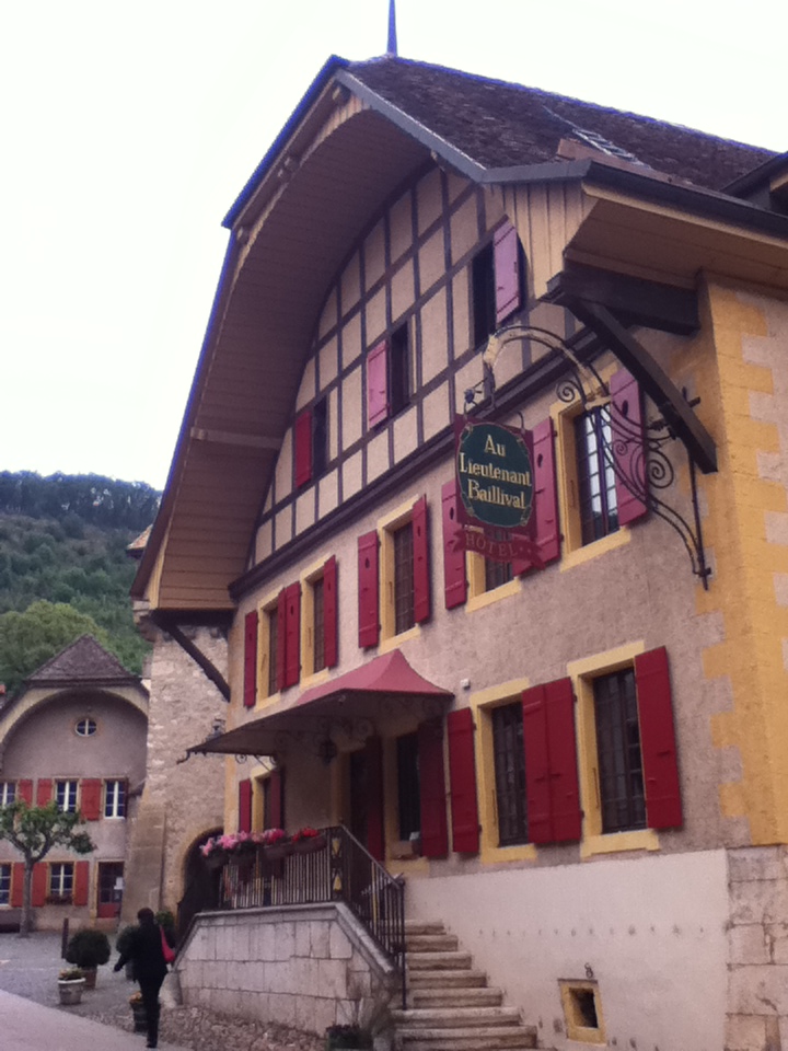
Successive visits also have a way of feeding upon themselves, so that each later experience is enriched by previous exposure.  For example, I wrote earlier about a short visit TS and I made to the village of Romanmoitie in the French-speaking canton of Vaud.  When we decided to re-visit the area with our Philadelphia friends, I remembered an interesting-looking inn that stood opposite a café where we’d had coffee there before starting our hike.  I looked it up online and booked a couple of rooms.  When we arrived we found it was even more eccentric and magical than we’d expected.  At our host’s recommendation, we dined at an excellent restaurant on the outskirts of town, where my chance TS and I had had coffee near the end of our hike on our previous visit.


The following day, we ventured into new territory, the northern shore of Lake Geneva.  Our visit to Lausanne was not completely successful – the city is most difficult to explore by car – but once we managed to find the Cathedral we did enjoy our visit.  A late lunch in Vevey was pleasant but we didn’t much care for what we saw of Montreux as we drove through its main street, because it was crowded and seemed rather over the top.  But when we reached our goal, the amazing Chateau de Chillon on the banks of the lake, we were entranced.  It is definitely the most perfect castle we’ve ever seen.  Even the dungeon, which inspired Byron’s poem “The Prisoner of Chillon,” is the epitome of a Romantic dungeon.

So, when it came time to plan my family’s visit in July, I knew we should make a day trip to Chillon, especially because it was the BIL’s first visit to Europe and it was important to show him Old Things.  We set out early, because I knew from my previous visit that it can get crowded, and we were able to explore the many, many rooms at our own pace.  The weather was a bit better on this second visit, though we still could not see the high peaks that loom above the southern, French, shore of the lake.

Lunch at the Cafe Metropole
Despite my previous experience of Montreux, I decided that it would be nice to go there for lunch.  We found a parking garage in the center of town, and had much more fun strolling along the lakefront, easily understanding why this area is known as the Swiss Riviera.  It was fun to see up close the statue of Freddie Mercury, who died in Montreux.  And we had a delightful lunch directly overlooking the lake at the Café Metropole, where the food and the service were exemplary and not as expensive as one might expect.  I’ll definitely return there when I next return to Montreux, with who knows what other visitors.

Coming Soon: Celebrating the Swiss National Day

Friday, July 8, 2011

Valleys within Valleys


Yes, it has been an unconscionably long time since my last report.  The Spouse and I have been hosting the first wave of summer visitors and doing a lot of traveling of our own, and my free time has gone to studying German and getting admitted to the local rowing club.  Each subject will be discussed in due time, but I thought I’d begin with a survey of our continued exploration of Switzerland’s valleys.

Lauterbrunen Valley
Faithful readers will remember our first ecstatic experience of the Lauterbrunen Valley last fall.  We have returned there twice since then and have traveled to other well-known valleys such as Davos.  But, increasingly, we have realized that Switzerland has an inexhaustible supply of beautiful mountain valleys, each with its own network of challenging and breathtaking hikes.  Even if we explored a new one each week I doubt that we would be able to catch them all in our time here.  But we are giving it a good try.


When you first think of Switzerland, most likely you think of its mountains.  But from the point of view of daily life, the valleys are more important.  In that sense Switzerland can be seen as a dense network of valleys.  Some, like the Lauterbrunen, deadend into high mountain cirques.  

Furkapass 
Others connect to other valleys by means of steep mountain passes.  Most valleys have others opening off them at right angles, so that when you begin to explore one valley you discover others that you want to return to.   


For example, our first hike of the spring was in a valley that opens above the town of Meiringen in the Haslital (tal being the German word for valley).  In early May we returned to this second valley, the Reichenbachtal, for further exploration.  (The literary among you might recall that Sherlock Holmes met his death in a fall from the Reichenbach Falls, which mark the river’s abrupt descent into the Haslital.  In recognition of this connection, Meiringen has a bronze statue of Holmes in its main square.)

This time we started our hike farther into the Reichenbachtal and hiked into the hills above it.  This afforded striking views of the Wellhorn and Engelhorner peaks on the opposite side of the valley.  While I was back in the U.S., The Spouse made a solo hike into the Urbachtal, which opens off the Haslital just to the east.


Rosenlaui Hotel in April
Returning to the valley also allowed us to revisit an interesting mountain hotel at Rosenlaui, in the heart of the mountains, which had been closed on our first visit.


Several weeks later in May we decided to check out Glarnerland, a valley that we passed during our trips to Davos last winter.  It’s named after its major town Glarus and a major peak the Glärnisch.  This time we got a head start by taking a funicular railway, called a Standseilbahn here, to the village of Braunwald.  In the winter it is the heart of a ski area and in the summer is full of charming vacation chalets, but we were ahead of the season so most of the shops and restaurants were closed.  (It has been a recurring theme of our hiking career so far, that we set our sights on a relaxing coffee break at a particular restaurant marked on the map, only to discover when we arrive that it is closed.  Peak hiking season doesn’t begin until late June or early July.)  Nonetheless, we were treated to spectacular views and fresh displays of mountain wildflowers. 

At the end of the hike, instead of returning the way we had come we decided to drive over the Klausenpass, said to be the longest pass in Switzerland, that connects Glarnerland with the Schächental, leading in turn to the town of Altdorf and the Vierwaldstättersee (Lake Lucern to the English – and you can’t know how proud we are of having learned to pronounce that!), which lies to the south of Baar.  For those who aren’t crazy about winding narrow precipitous mountain driving, I wouldn’t recommend this road to you, but it is entertaining, especially when you meet packs of bicyclists or motorcyclists on one of the many hairpin turns.  The pass reaches 1,948 meters (6,393 feet), and I couldn’t imagine riding a bicycle over it, but the Swiss are intrepid bikers and seem to think it makes for an entertaining Saturday jaunt.

We were so delighted with the Klausenpass that we drove it the other way a few weeks later to show off the mountains to a visiting friend.


And a few weeks later in search of a pleasant Sunday afternoon hike, we returned to the Altdorf area and rode a small mountain tram to a plateau above the Vierwaldstättersee and then hiked above the Schächental.  From there we could see a number of other valleys that bear further exploration.

The Rhone, with Glacier in Background
One of the great valleys of Switzerland is named, appropriately, Valais, in French, or Wallis in German.  It opens at the far end of the Furkapass, with a glacier that is the source of the Rhone River.  This valley is so big that it fills an entire canton in southeastern Switzerland.  As the Rhone flows eastward it grows and the valley widens, its steep sides affording perfect conditions for vineyards that produce some of the finest Swiss wine.  So, one rainy Saturday we decided to drive over and see what we could discover.

Lötschental Valley from Fafleralp
We discovered not only the beauty of Valais, which will bear much further examination (and visits to vineyards), but yet another valley, the Lötschental.  The steep cliffs guarding its entrance into the Valais kept the Lötschental isolated from the outside world until recently, especially in the winters.  It is famous for a number of colorful folk traditions that have been preserved, including carving of grotesque wooden masks used at Fasnacht.  Today it is marked by a line of charming villages that have only recently begun to be developed for tourism.  We followed the ever-narrowing road to its end at the village of Fafleralp and found a wonderful mountain hotel that fortunately had a room available.

Langgletscher, with stream flowing out of ice cave
The following morning we headed beyond the road’s end up to the Langgletscher, one of the most southerly of a huge network of glaciers known as the Jungfrau-Aletsch, which collectively has been designated by UNESCO as a World Heritage natural area.  Looking up at the awesome and slightly menacing glacial forms, one has a sense of the inhuman power of the mountains and the natural forces that have carved them over millennia.

View from Furgglen Restaurant, opening of Glarner valley in distance
Finally, last weekend we traveled east toward the Wallensee, a large lake bounded by awesome uplifted cliffs that we had passed during previous trips.  We drove to the village of Amden and then rode further upward on a Sesselbahn, a chairlift, to reach the starting point of a lovely hike through yet another mountain valley.  From its heights we could see the opening of Glarnerland, one of our previous discoveries.  We enjoyed a coffee break at one of the many mountain restaurants that have opened, in which farmers offer food and drink for hikers in addition to their usual summer activities.

For all their similarities, each valley offers stunning new views and new opportunities to explore.  Each time we go out we learn a little more and, I hope, gain strength to take on the steep parts!
 
Bis später! Until later!

Wednesday, May 4, 2011

A Tale of Multiple Springs

Officially spring begins on March 21, but we all know that the moment when Spring actually arrives – that magical day when all the world seems new-born – varies widely from place to place.  Having grown up in Wyoming, where Spring arrives over a single afternoon sometime in late May, I have enjoyed the ability to savor the longer unfolding process in Pennsylvania.  I treasure the first careful emergence of daffodils in early March, watch eagerly as the first Hosta spearpoints poke out of the soil, and carefully measure the gradual unfolding of leaves on the larger trees.  As azaleas make their exuberant appearance later in April, I begin to feel a bittersweet sadness, knowing that soon the world will be enveloped in green and we will forget that tree branches could ever have been so dark and bare.

Here in Switzerland, the unfolding process also varies by altitude.  After a mild winter, Spring arrived early this year in the valleys but it is still working its way upwards into the high mountain meadows.  Meanwhile, back in the United States was late in arriving after a long, hard winter.  Not only in Wyoming, where being caught in an Easter blizzard is one of my favorite childhood memories, but even in generally moderate Pennsylvania, Spring was several weeks late in arriving this year.  Hence by means of some well-planned travel I have been able to experience those magical early moments of Spring over and over.

On weekdays after TS gets home from work we have taken advantage of the lengthening daylight to walk out into the hills around Baar.  Each time we observed new hints of spring, from planted flowers and bushes in town to wildflowers in the fields and along the streams.

On a weekend walk around Baar, we noted that members of the local gardening association -- which seems to confer possession of a substantial allotment on the edge of town -- had already been hard at work.
By the end of March in Switzerland it became clear that the oft-promised late-winter snowfall was not going to materialize and The Spouse and I reluctantly put away our skis and dusted off our hiking boots.  Our first foray was a hike above the village of Meiringen, about an hour from Baar in the heart of the Bernese Oberland.  It was a perfect way to launch the hiking season, for although the hike was long it wasn’t unduly arduous.   

After the inevitable climb up the valley walls we entered another valley between stunning peaks.  For about the last hour, snow on the path forced us to walk along a paved road instead.


The following weekend we decided to venture west into the canton of Vaud, in the French-speaking part of Switzerland.  We visited the village of Romanmoitie, site of a lovely Romanesque Abbey and hiked into lush countryside around it.  All around were signs and smells of Spring in full bloom.

Living in the midst of active farms, we also observed the arrival of Spring in the animal world.  In early April newly-born kids – the real kind – appeared in one field; a few days later we saw tiny lambs, so recently born that they could barely stand.


At that point, I left Spring behind and returned to Philadelphia for a visit.  I was surprised to find that the season was about two weeks behind that in Switzerland.  In fact, the entire east coast was in the throes of turbulent weather more suited to early March.  Although Pennsylvania was spared the tornadoes that devastated North Carolina (and that would wreak havoc in Alabama and Mississippi later), heavy rainstorms resulted in flooded rivers that kept me from my beloved rowing for some days.  But the late arrival of the season allowed me to re-experience the arrival of Spring when the weather turned suddenly warm on Easter day.  As the temperature soared above 80 degrees Fahrenheit, the grateful city poured out to soak up the sun in the city’s parks.

Back in Switzerland last week, we took another Sunday-afternoon hike into hills around the Ägerisee, a lake in the next valley east of Baar.  (Yes, indeed, it really is one stunningly beautiful place after another here.)  We walked along the lake and then up a steep hill to circle back at a higher level.  Amazingly, even now the rise in altitude afforded took us back to an earlier stage in the growth of vegetation. 

Returning we descended through pastureland filled with dandelions, buttercups and cows seemingly as happy with the sights, sounds and smells of Spring as we were.